The Historic Elk Run Anglican Church Site
1999-2006
Compiled By Edward F. Dandar Jr. (COL, USAR Ret.)
Chairman, Elk Run Church Site Preservation Committee
Acknowledgments
Many people have been helpful and kind. The person most productive in compiling the research for this effort leading up to the transfer of the Church Site Deed, and beginning archaeological work was Ms. Jackie Lee, former Director of the Old Jail Museum. Others included Archaeologist, Dr. Pat Curry, who volunteered to get us started on our journey in November 1999.
Most importantly, Archaeologist, Dr. John Eddins volunteered in the Spring of 2000, and tutored and guided more than 129 volunteers over a seven year period from April until October each year on most good weather Saturdays. During the winter months, Dr. Eddins supervised the cleaning of artifacts uncovered during the previous archaeological season. Dr. Eddins got the of State of Virginia to register the “Elk Run Anglican Church” Archaeological Site as 44FQ179.
My special thanks to all the Volunteers, many of whom returned in subsequent years to work on Saturdays, in good weather in spring, summer, and fall to help expose the foundation of the church and dig controlled excavation units for recovery of colonial artifacts and building materials. On weekends during the winter months, they cleaned and identified the artifacts recovered from the site. See an overview of the Volunteer Effort.
Another key person was Norman Williams who assisted me on most weekends in getting the site ready for work, and documenting our many years of effort with photography. It is his photography that is used in this report to better inform the reader of the actual events. Church Administrator, Karen Pickrell, provided critical administrative support during the entire seven year effort.
Other individuals that I am indebted too for making the Elk Run Church Site Preservation Project a successful effort are the following: the Ned Browning Family who donated the historic site to St. Stephen’s Episcopal Church, Bob and Sabinia Flournoy, Rev. Roma and Paul Maycock, Richard Gookin (Committee Treasurer), Elizabeth Gookin, Rev. James Hammond, John Toler, Sarah Gulick, the William Gulick Family, the Greg Miller Family, Jim Olmstead, Pete Petrone, Dr. Bill Hanna, Becky Garber, Brenda Branscome, Dot and Bill Wright, Phyllis Scott, Mark Digiulian, Michael Wade, Jeff Woodward, Lory Payne, Ray and Mary Root, Morris Payne, William and Jackie Patton, Dr. Carl Lounsbury, Director of The Williamsburg Foundation’s Architectural Department, The Margaret Spilman Bowden Foundation, David Buckwalter, Butler & Eicher, Karl Hertag, Boy Scout Troop 1177, and the Fauquier 4-H Club.
I want to sincerely thank the Fauquier County Board of Supervisors, who provided grants during the 2001-2006 important phases of the archaeological effort: everyone who donated funds, materials and services; and all those who came out and helped us dig up some Fauquier County history. To these individuals, and the many volunteers who helped over seven years at the Dig Site, I am most grateful.
Foreword
The purpose of this Summary Report is to bring together in one document the seven years of the all-Volunteer Archaeological Elk Run Church Site effort. The technical content in this report is from Dr. Eddins’ notes provided over the years for the Preservation Committee’s Annual Reports. The historical research captures key aspects of Church life and the Elk Run community.
The sources of historic research for this effort have been many. To name a few:
1 Harry C. Groome and Harry Connelly Groome, Fauquier During the Proprietorship: A Chronicle of the Colonization and Organization of a Northern Neck County ; (Fauquier Co., Virginia; Regional Publishing Company, 1927), 200.
2 Fairfax Harrison, Landmarks of Old Prince William, A Study of Origins in Northern Virginia in Two Volumes, (Berryville, Virginia; Chesapeake Book Company; 1964), 514.
3 Gertrude E. Gray, Virginia Northern Neck Land Grants, Volume I: 1694-1742; (Baltimore, Maryland Reprinted for Clearfield Company by Genealogical Publishing Co., 2008), 72.
4 Ruth and Sam Sparacio, Prince William County Order Book Abstracts, 1752-1753, (Antient Press), 47.
5 Groome and Groome, 197.
6 Washington, George, 1732-1799. The writings of George Washington from the original manuscript sources: Volume 1 Electronic Text Center, University of Virginia Library.
7 Gail Raney Fleischaker, “Reverend James Keith and the Elk Run Church,” www.elkrunchurch.org; Joan Gunderson, The Anglican Ministry in Virginia, 1723-1766: A Study in Social Class (New York and London: Garland Publishing, Inc., 1989) 262.
8 “The Elk Run Community and Church” See History Section
Elk Run Church Site Archaeological Summary Report, 1999 – 2006
Introduction: For more than seven years a team of enthusiastic volunteers worked in an open field in southern Fauquier County to locate, uncover, and document the remains of the old Elk Run Anglican Church. Elk Run Church was built on this site in the 1750s, to serve the needs of the expanding population moving west across the piedmont from the tidewater areas to the east. Elk Run Church served as a center of community activity for several decades. Church membership declined in the latter part of the eighteenth century when a new church was established closer to the town of Warrenton. Membership further declined following the Revolution and the disestablishment of the Anglican Church in the newly formed United States.
By the first or second decade of the nineteenth century, Elk Run Church was abandoned and fell into ruin. For almost 200 years the remains of the church rested in the farmland soil of Fauquier County covered by briars, shrubs, and cedar trees. The remains were relatively undisturbed, being too difficult to plow through productively. The former location of the church site was remembered only by a few local residents with long-established family roots in the county.
Purpose: To preserve the 1740s Elk Run Anglican Church site and its history so future generations will have knowledge of its past and an appreciation of our forefathers’ contributions to the settlement of Fauquier County. This southern Fauquier County site is significant because it was the first Anglican Church site established in what was the County’s mid-1700’s frontier area.
Early History: Settlers first arrived in the Elk Run area during the 1715-1719 timeframe. By the 1730 establishment of Hamilton Parish, there were several hundred people living in the Elk Run vicinity of Virginia.
A wooden Chapel is believed to have already existed by the 1740s when Prince William Minute Books made note of road repairs being done in front of the Elk Run Chapel. The Chapel preceded the pre-Revolutionary brick cruciform structure that was built in the 1750s. The 1755 Fry-Jefferson Map is the earliest map that shows Elk Run Church.
The Church served respectively as a governing and administrative body under British colonial rule, and the bustling village of the 1750s boasted a tavern, a blacksmith shop, and an ordinary that was a stopover point for travelers going north or west in the constant expansion into what later became Fauquier County.
Colonial militia fighting in the French and Indian War (1754-1763) and military forces during the Revolutionary War (1775-1781) stopped at Elk Run for rest and supplies.
The only description of the Church was when Bishop William Meade of Virginia wrote in 1857, “It was a substantial brick church-cruciform, I believe. I am not certain that the roof was on it when I first saw it in 1811. Its walls continued for many years after this, and I saw them gradually disappear during my annual visits to the convention.”
The pre-Revolutionary brick cruciform structure was built in the 1750s during the ministry of its first Rector, the Reverend James Keith, a native of Scotland who served as Rector from about 1742 until 1752. Reverend Keith’s grandson was Chief Justice John Marshall.
Location: The old Elk Run Anglican Church Site is in Cedar Run District, Fauquier County, Virginia. It is located on the south side of VA RTE 806 (Elk Run Road), approximately 0.05+ miles west of the intersection of RTE 610 and RTE 806.
Background: The Elk Run Church Site Preservation Project began in February 1999 when a group of concerned local citizens led by Edwin Gulick, Ed Dandar, Bob Flournoy and Jackie Lee organized to carry out research on the church and explore ways to preserve and celebrate the site. After Community discussions and collaboration with St. Stephen’s Episcopal Church (Catlett, Virginia) and St. James Episcopal Church (Warrenton, Virginia), St. Stephen’s led a Community effort in acquiring this historical property. Rev. Roma Maycock, Rector of St Stephen’s Church, and her husband Paul Maycock were strong supporters of this effort from the onset.
Ed Dandar drafted a Preservation Plan and presented it to Mr. Edward Parry Browning III, owner of the property and a descendant of the Reverend James Keith. After two reviews of the Plan, Mr. Browning approved the Plan being assured that this property would be preserved as a historic site. On June 23, 1999, Mr. Browning generously deeded the approximate 100 foot by 100 foot lot to St. Stephen’s Episcopal Church.
When St. Stephen’s Church took possession of the site in June 1999, it was simply a vacant lot with bits of old brick lying about. They had no knowledge or assurance that anything lay below the surface, nor could they be certain that the church was actually located there.
In November and December 1999, with the help of Archaeologist, Dr. Pat Curry, the volunteers excavated three controlled test units at the site, to expose a corner of the church foundation to see what sort of remains were actually present at the site. The test units revealed a mortared stone foundation that was relatively intact. Volunteers began to uncover the remains of what was the first brick Anglican Church in Fauquier County’s mid-1700s frontier.
The volunteers of the Elk Run Anglican Church Site Preservation Program were concerned that the investigations they wished to have carried out at the church site were done properly. They wanted to insure that all the important information encapsulated in the archaeological site was recognized and documented so that nothing would be lost. They requested bids from professional archaeological firms for limited testing at the site and found that such work was quite expensive.
However, Dr. John Eddins, a member of one of the firms, a local resident, and a professional practicing archaeologist, offered to supervise a professional level dig at the site, manned by the numerous volunteers who had expressed an interest in participating. Dr. Eddins got the State of Virginia to register the “Elk Run Anglican Church” Archaeological Site as 44FQ179.
Archaeology Overview: The program of excavations started in late April 2000. An initial objective was determining the size and shape of the Church in order to complete the State Historical Highway Marker submission by 15 June.
By mid-May 2000, under the guidance of Archaeologist, Dr. John Eddins, the volunteers embarked on a program of systematic excavation at the site intended to:
- fully expose the foundation
- reveal the true shape and size of the church
- recover information about the methods and materials used in construction
- locate any entrances, stairways, and other features and any remains of activity inside and outside the church
- collect a sample of the material culture left behind by the people who had used the site
- determine the location of any burials and other features in and around the church
- generate detailed maps, measured drawings, and comprehensive photographic documentation of the church foundation, the cemetery, and any other historic and prehistoric features encountered
- produce a detailed technical report and a more general popular report on the results of the archaeological investigations.
The work of the volunteers was guided by the need to carefully expose and properly record the architectural remains, artifacts, and evidence of human activity in the soil.
Following Dr. Eddins guidance, the site was excavated over a series of extended excavation seasons from 2000 to 2006. The site was excavated using techniques that maintained strict control over the vertical and horizontal spatial relationships of all components of the site. A site grid, establishing a Cartesian coordinate system for specifying locations anywhere on the site, had initially been established by Dr. Pat Curry in late 1999. The grid was used by the research team to help them keep track of the spatial relationships of everything found at the site.
This site grid was re-established using a digital transit and survey stakes so that the location of all new work and any recovered archaeological remains could be precisely recorded. A site elevation datum, for recording the vertical location of remains, was also established. All the excavation units that were dug by the volunteers were positioned and recorded in relation to the site grid. The architectural features and other evidence of human activity were mapped in relation to the grid. All maps and scaled drawings were tied to the grid.
Photography of all the archaeological activities at the Elk Run Anglican Church Site and in this Report was provided by Norman Williams.
The Elk Run Preservation Committee Web Site was established on February 21, 2000 with the assistance of Rev. James Hammond, Rector of St. Luke’s Episcopal Church in Remington, to inform the public of its work and to share its research and findings. The Web Site later included historic map extracts, numerous photos of archaeological activities, artifacts, and genealogy items.
Archaeology Activities Begin

In December 1999 volunteers found an initial part of the Church foundation under the guidance of volunteer Archaeologist, Dr. Pat Curry.
After the site grid was reestablished by Dr. Eddins in May 2000, the volunteers used soil probes and pin flags to attempt to locate the edges and extent of the foundation. Pin flags were placed wherever a possible foundation wall edge was located.
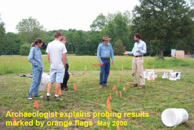
Large amounts of brick and stone rubble were spread across the site and that made it difficult to quickly isolate the edges of the foundation. However, gradually the placement of pin flags near possible wall edges produced a pattern that identified the general location of the inner and outer edges of the extant foundation.

Upon completion of foundation probing and searching for the corners, excavation units were then positioned to uncover the corners of the structure. Over the course of the field seasons, additional excavation units were placed around the foundation and in the interior of the church.

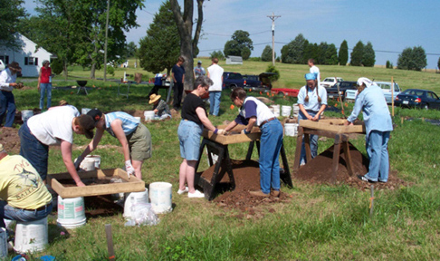
The volunteer members of the research team assisted in laying out excavation units, oriented to the site grid, using measuring tapes, corner spikes, and string. They also set up a datum near each unit to record elevations of the different soil layers and architectural features found in the units. As each successive layer of soil was removed in a unit, a member of the crew helped to take notes recording descriptions of the layers and other observations. Excavation units were dug in controlled levels by hand using shovels, trowels, and whiskbrooms.
One soil layer was removed at a time and all soil was screened carefully through wire mesh to enable recovery of small artifacts. A large magnet was used to assist in the recovery of tiny metal artifacts from the soil in the screens. Artifacts from each level of each soil layer were bagged together in the field in bags marked with the information needed to identify horizontal and vertical provenience. The bags were then stored for processing in the lab during the winter months. Brick and stone rubble and remnants of mortar and plaster from each level of each layer in each unit were weighed to create a measure of the density of rubble across the site.
The soil profiles as exposed in the side walls of the units were recorded in measured drawings and photographs. The base of each excavated level was carefully troweled to reveal any differences in soil color or texture that would indicate the presence of a feature, such as a posthole or pit.
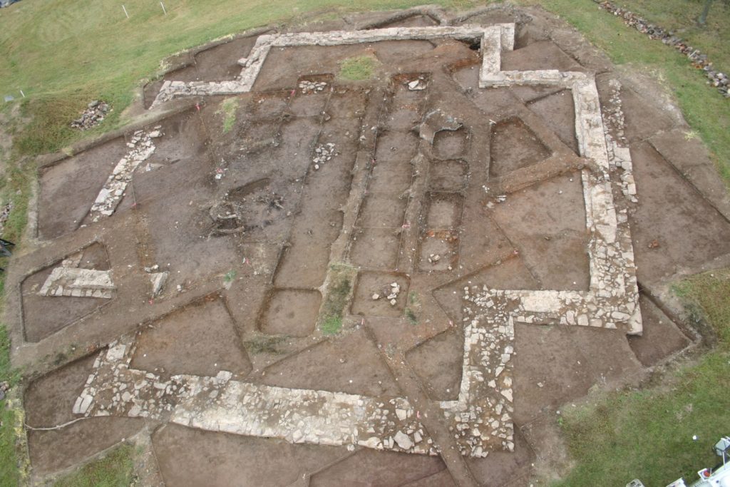
The excavation revealed a layering of soil and building debris across the site that consisted of turf and topsoil, overlaying a rubble layer, overlaying subsoil. The rubble layer included a mix of broken and decayed brick, mortar, plaster, and foundation stone that varied in thickness across the site. The vast majority of the rubble layer was contained within the foundation of the church, indicating that the walls fell inward as the building disintegrated.
Pockets of window glass within the rubble indicated the general vicinity of windows in the walls of the church. The foundation of the church was placed in a builders trench dug down into subsoil, and was overlain by extensive amounts of rubble from fallen walls, topsoil, and turf. The soil strata were mixed in places due to the activity of tree roots over the years, and other disturbances.
Details of the Archaeological Research Program:
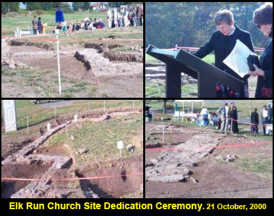
By June 2000, volunteers uncovered the corners of the cruciform foundation, photographed them and the State Historical Highway Marker Sign language was finalized by the State Historic Resources Department.
On October 21, 2000, the historic site was dedicated with the unveiling of the State Historical Highway Marker.

The importance of the site was further noted in the in the dedication address when Dr. Carl Lounsbury, Director of The Williamsburg Foundation’s Architectural Department, commended the Committee for adding another chapter to Virginia’s Colonial Church History.

Initial Cemetery Search: According to documentary research and oral history interviews with local residents, a cemetery associated with the Elk Run Church was located in that area.
On December 9, 2000, the research team attempted to recover evidence of the suspected adjacent Church Cemetery. A series of test trenches were carefully excavated using a backhoe with a smooth shovel for the removal of the plow zone and exposure of the subsoil, in an adjacent parcel of land, between the church parcel and the location of Elk Run. The results of this process yielded about five “spots” where the soil changed, indicative of possible burials.

After careful limited testing to open a window into one of these potential graves, one grave shaft, containing skeletal remains in an excellent state of preservation, was exposed. The grave and skeletal remains were oriented east/west in the manner of Anglican burials during the 18th century. By the end of December, the adjacent cemetery was confirmed.
Several other as yet unidentified features were recorded, including the possible location of the brick kiln used to produce the brick for construction of the church.
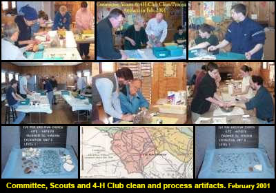
In February and March 2001, systematic cleaning and processing of the Artifacts recovered from 27 excavations during Year 2000 was completed by Volunteers composed of local Elk Run neighbors, Boy Scouts, 4H Club members and church parishioners.
Use of Remote Sensing In the Church Interior and Suspected Cemetery Area
Archaeological fieldwork resumed in late April 2001. In July 2001, the Elk Run Church Site Committee sought use of 21st Century remote sensor technology to non-intrusively sense objects or structural features beneath the ground surface.
Pro-bono remote-sensing investigations were carried out at the Elk Run Church site by Petrone & Associates in July, 2001. Remote-sensing methods are used to sense objects or structural features beneath the ground surface using various techniques. Remote-sensing techniques can also be used to identify the location of potential graves. Petrone & Associates relied on ground-penetrating radar (GPR) and electromagnetic and magnetic-gradiometry systems.
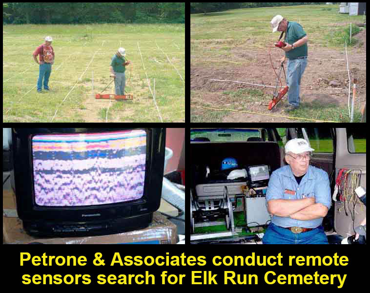
Petrone & Associates were successful in conducting remote sensing that helped define church cemetery boundaries, possible positions of burials within the cemetery, and areas that might have further archaeological significance.
Petrone & Associates’ geophysical surveys provided evidence for the locations of subsurface archaeological features, including some east-west structures that may be related to burials within the cemetery adjacent to the church.
Many of the mapped echoes on adjacent GPR lines are aligned east-west, the traditional direction for human burial. Many other echoes are aligned northeast-southwest, essentially parallel to nearby Elk Run Road, and they may mark locations of structures, such as wall foundations or old trenches. The GPR and magnetic data suggest the possibility that a brick wall once surrounded part of the cemetery. The magnetic-gradient data also may indicate the presence of fired features, such as a brick clamp.

The Petrone & Associates Report was received in late November and, once reviewed, the Committee discussed further Church Cemetery exploration and archaeology work with the Patton Family, who are the adjacent property owners. An overview of all cemetery work accomplished at that time is shown in this report.

In the summer of 2001, Dr. Eddins completed a digital survey of all 27-excavation units. Dr. Eddins later prepared a scale drawing showing the location of all excavation units that was used in an Artifact Display Case to show where different artifacts were found.

The Elk Run Church Site Preservation Committee, in addition to its press releases, continued to use its Web Site with new Webmaster, David Buckwalter, to inform the public of its ongoing work and to share its research and findings. The Web Site included historic map extracts, numerous photos of archaeological activities, artifacts, and genealogy items.
Archaeological excavation work was expanded from 28 units in October 2002 to 54 units in 2004. Archaeological fieldwork resumed on 8 May 2004. Key objectives included finishing Units #47 through #50, adding units #51 through #54, and continuing documentation and photographing of all excavation units. Of significance was finding the foundation for one of the piers that would have supported a wooden floor structure for the Church.
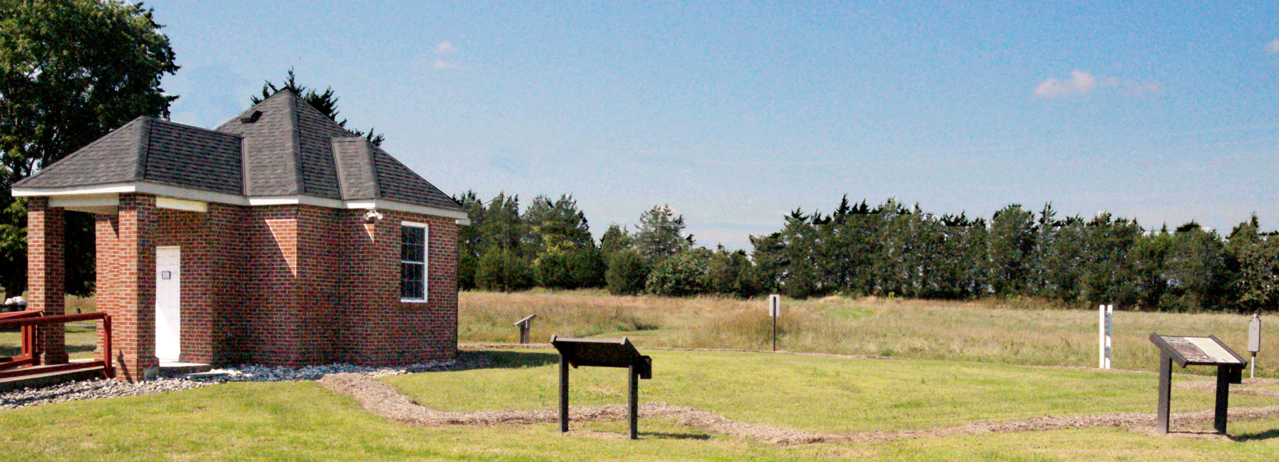
The Web Site was updated in subsequent years by Sarah Gulick and provides good coverage, especially photos, of what was accomplished during 1999-2006 on the Archaeological Dig effort, and what has been accomplished since October 2006 in transitioning the Dig Site into a Historic Church Park, including the completed construction of the Mini-Museum in 2010 that exposes a segment of the original foundation. A 10-minute Video Documentary on our efforts up to 2007 was produced by Sarah Gulick with support from Marymount University, Studio UP (www.studioup.com) and shown at the Williamsburg’s 400th Anniversary of Jamestown, Virginia.
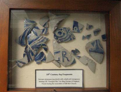
The all-volunteer archaeological effort from November 1999 until October 2006 exposed the 1750s Greek cross foundation. The artifacts found range from different size nails; broken church window glass; salt glazed pottery fragments; plaster wall fragments; clay pipe stem; 18th Century “pieces of eight” Spanish coin, and other 18th and 19th Century coins; a Colonial clothing button; broken brick pieces; and Indian arrowheads dating back 4000 years or more.

Volunteers included local residents, church members, grade school, high school and college students, Boy Scout troops, and visitors from outside the county and the state.
Lab Work

The artifacts recovered from the excavation units during the annual field seasons were cleaned and processed by the volunteers in weekend lab sessions during the winter months. Artifacts were systematically cleaned, dried, and re-bagged in new plastic bags with Id tags, and stored in storage boxes. The artifacts were sorted into different artifact types and logged in a preliminary site catalog.
With the end of field work at the site, the volunteers redirected their efforts toward identification, description, and quantification of the recovered artifacts. Research will be carried out to help us correctly identify and more fully characterize the origins and functions of the artifacts.
Representative sets of the artifacts with associated descriptive text and copies of photos and drawings from the site have been encased and placed on public display at various locations throughout the wider Fauquier community.
Summary of Remains Encountered
Based on the results of our multiple field seasons at the Elk Run Church site, it appears that the Elk Run Church was an edifice very similar in size and form to Aquia Church in Stafford, Virginia, which was first built in Aquia in 1751. The Elk Run volunteers exposed the complete foundation of the church, which consisted of mortared stone, with a few remnant bricks from the first course of bricks. The Church stone foundation averaged about 3.5 feet wide and measured approximately 57.5 feet on a side. The brick walls which sat on the foundation were about 2 feet wide and measured about 55.5 feet on a side. The Elk Run Anglican Church was laid out as a true symmetrical Greek cross. The arms, head, and foot of the cross each extended a little over 10 feet out from the core of the church, and were a little over 36 feet wide.
No subsidiary features or outbuildings were located outside the foundation of the church. However, flat stones located adjacent to the exterior edge of the foundation on the western side of the church may have served as the base for steps at the main entrance. Evidence for the remnants of bases for several stone piers was the only definite features located on the interior of the church.
These piers may have been used to support joists that served as the frame and support for a wooden floor across the interior of the church. This correlates with a lack of evidence for the presence of stone pavers or bricks used as flooring, or for the sand layer used as bedding to level bricks and pavers. A rim apparent along the interior edge of the foundation may also have served to support the joists.
A large depression was exposed in the eastern arm of the cross, most likely the chancel area where the altar was located. The depression, which extended well down into the subsoil and was filled with rubble from the collapse of the church, may have been caused when a tree growing in the interior of the abandoned church tipped over. The depression could also have been caused when potential looters attempted to dig into the altar area of the abandoned church to explore for valuables associated with burials.
The roof was likely covered with wooden shingles. No evidence of slate shingles has been found during our excavations. The interior of the church was covered with white-washed plaster. The quantities of window glass recovered indicate that the church had multiple windows on each side. No direct evidence of other interior features was recovered. Few whole bricks were found, indicating that the church site was systematically ‘robbed’ over the years for building materials that were likely used in structures throughout the surrounding countryside.
The site continued to be utilized in a casual way over the years through the nineteenth century. A few coins dating from the eighteenth, nineteenth, and even twentieth century located in the ruins seem to verify such a conclusion. There is even reference to Civil War troops using the remains of the church as a temporary campsite.
Ultimately, 54 units were excavated by the volunteers. A total of 129 volunteers provided over 5,803 hours of service between 1999 and 2006.
